The Mystery of Cherry Lake.

Cherry Lake is the name of a private residential community in Newport Beach. The lake that gives the place its name sits roughly 26 feet above sea level on the northern bluffs of the Upper Newport Bay. Its depth is 17 to 19 feet. It is long, rather than wide, and lozenge-shaped. A water-gate prevents debris from being swept into it from a depressed area that runs from the intersection of Santa Isabel Avenue and Redlands Street. There is a concrete dam on the southern edge that impounds the water with two six-foot pipes inside a catch basin. When it rains fiercely, the impounded water overflows into the pipes that run underneath Irvine Avenue at 23rd Street and through the Santa Isabella Flood channel that drains into the Upper Newport Bay.

Twenty houses ring the lake and many of them have docks. “I’ve seen those docks underwater,” Rodney Medler told me. I’d left a note on his door—can I see the lake? —and he’d called and invited me over for a look. Medler, a retired property manager with the rakish good looks of the actor Sam Elliott, lives on 23rd Street. His backyard faces the lake, and he also has a camera trained on it, so that even when he isn’t outside, he can see it, the better to catch lake-crashers (they’ve had some). Cherry Lake has lily pads. When they die off in the fall, the tuberous roots, which are a ghastly greenish-white, float near the surface of the water, looking like the arms of a monster: the Cherry Lake kraken, perhaps. There’s a slide in the middle. People swim in the lake. It’s a special place.

Cherry Lake has a distinctly retro feel to it. The name hearkens back to the technicolor gloss of the post-war era in Newport Beach. Back then, the colors were bright, and women wore coral-colored lipstick as they water-skied in the bay or drank cocktails at the Village Inn on Balboa Island with their handsome husbands. In those day, everything was gay, and people lived their lives gaily, according to the local newspapers, the Newport Ensign and the Daily Pilot, who never hesitated to use this adjective to describe the mirthfulness of everyday life in Newport.

There was no water skiing on Cherry Lake, although there was fishing. “There are fish in there— bass, catfish, bluegill,” said Rodney. “We fish. But we just catch and release though. They’re like pets!”  A woodpecker flew across the lake just then, in a flash of black and white.

“Look at that!” said Rodney. “We get all kinds of birds here. We got some ospreys last year.”

“They must love the fish!” I said.

“Yeah,” Rodney said. He laughed. “We make it easy for ‘em.” The lake was different, he told me. Not only was the bottom unlined, it was spring-fed.

“There are six springs in the lake,” he told me genially. “When you swim, you can feel the water temperature drop. And that’s how you know.”

I’d heard about the spring: it was the lake’s creation myth. But there was nothing plausible about the lake (coastal lakes are relatively rare in California.) It was obviously man-made. But by who?

It was a joint effort. Lawrence E. Liddle, the property owner, joined forces with realtor Jack W. Mullan in 1956, according to papers filed with the Newport Beach Planning Commission. Together, they built a lake.

Picture of Jack W. Mullan ((1924-2004) from the Smithsonian National Air and Space Museum.

Both men took their cues from the recent past. In 1955 the Vogel Company, a realty firm, advertised a “lakefront” home on Cherry Lake, with guaranteed swimming rights. A year later, the Soil Conservation Service of the Department of Agriculture graded the area and installed a desilting basin. How Cherry Lake fared during this rough treatment is unknown. But community memory is tenacious, and the recollection of what the site had been probably encouraged Liddle and Mullan.

Liddle, born in British Columbia, kick-started the development of Cherry Lake, appearing as the principle of “Lake & Bay Park, Inc.”. He drops out of the historic record as represented by city filings and newspaper mentions after a time. Mullan, however, stayed in the news until his death in 2004.

Mullan, an adventurous man, was a big-time developer in Newport Beach. As the vice president of the California Real Estate Association in Orange County, he designed neighborhoods out of the raw materials of the Southern California landscape. His large-scale vision was acquired during the war after enlisting in the Air Force. He flew P-38’s, the workhorse fighter aircraft that could bomb landscapes or document them. A renowned photo reconnaissance pilot, Mullan was trained to do the latter, and continued to fly them after he and his wife moved to Germany after the war. Mullan managed the operations of the Aero Exploration Company, based in Tulsa, Oklahoma a firm that specialized in aerial photography. The company had an outpost in Frankfurt, then at a low point in its long history, the cityscape having been almost entirely destroyed from 1939 to 1945 in nine separate bombing sorties.

The view from the skies above war-scarred world stayed with Mullan, who found civilian uses for his Air Force training in post-war Southern California. Mullan “pioneered the use of aerial surveys in subdivisions” according to his brief biography on the Smithsonian National Air and Space Museum. He moved several times before settling in Newport Beach, and once there, began shaping the landscape of semi-rural Orange County.

Mullan didn’t just develop housing tracts, he provided “estates”, with an emphasis on exclusivity, and all the trappings thereof. Golf courses, clubhouses, private roads and lakes were popular design features of the exurbs, built for those in white flight from diversifying city centers. Mullan took all this to its fullest expression, and masterminded Orange County’s most iconic mid-century housing developments, the “Carriage Estates” in Mesa Verde, for example, which were located on the bluffs above the Santa Ana River.

His most enduring legacy is his credit as the co-designer of a new kind of housing development, called a “condominium”. He oversaw the design of the first legal condo development in California called Vista Bahia, appropriately: they (still) overlook the top of the Upper Newport Bay, at University Drive and Irvine Avenue. I marveled at the grounds of Bahia Vista as a child, walking to swimming lessons at the YMCA. The grounds were impeccable with coarse St. Augustine grass and sculptural hedges of Natal plum (Carissa macrocarpa).

Bahia Vista embodied Orange County’s two great loves, an expansive view and privacy. Mullan built it in anticipation of the coming population surge, which involved more people demanding more of everything housing, parking, and recreation except density.

He had some defeats. In 1965, the year I was born, Mullan headed the Newport Dunes Hotel Corporation, which intended to develop the Newport Dunes into a Spanish-themed 244-room hotel and restaurant complex, covering 6.4 acres, and facing “the quiet waters” of the lower bay. A fifty-year sublease was planned between Mullan and the county, but the plan was scuttled in 1967 due to bureaucratic hesitance to commit to the costs of construction. The complex was never built.

But Mullan still built plenty, some of it above the Upper Newport Bay. Within a decade, the bluffs between Mesa Drive and East 16th Street were transformed from small farms divided by eucalyptus windbreaks and dotted with ramshackle buildings into family homes plotted on streets whose names memorialized the cities of old Europe: Grenoble, Marseilles and Seville.

1907 Long Beach Press ad for prime land in Newport Heights.

In the mid-fifties, Mullan founded a realty firm and opened an office on the peninsula at 434 32nd Street in Newport Beach, close to Via Lido and just around the corner from my grandfather’s office, the Weist-Creely company, then selling parcels of augmented mudflat on Lido Isle for under one hundred thousand dollars. They were joined by P.A. Palmer, R.C. Greer and others, all of whom were jockeying to sell the undeveloped and sometimes barely terrestrial land of Newport Beach.

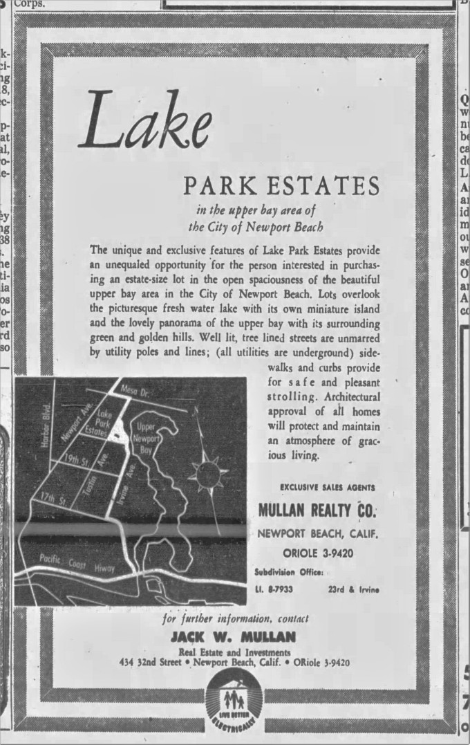
In 1958, after he was granted a permit by the city of Newport Beach to post subdivision signs, Mullan hung two advertisements outside a temporary sales office near the old ravine at 23rd Street and Irvine Avenue, and ran an ad in the Los Angeles Times, alerting the public to a new development with natural allure. “Lots overlook the picturesque freshwater lake,” the ads boasted, mentioning that all utilities were undergrounded, and all architectural designs subject to approval, in order to maintain the harmoniousness of estate life. (There was no mention of the lake’s decidedly un-glamorous stint a year or two earlier as a desilting basin). He and Liddle dubbed the development the “Lake Park Estates.”

The “freshwater lake” was, of course, Cherry Lake, a name not in keeping with the nature of the place. There are no lakes called “kirsch see” in Germany, but there are a few Cherry Lakes in Canada, where Liddle was born. Arranging the site must have been a monumental effort: Mullan, Liddle and their engineers had their work cut out for them. Cherry Lake, and the houses arranged around it, sit on top of what once was a 25-to 40-foot ravine.

Ad for Lake Park Estates, Valley Times, July 8, 1960

After talking to Rodney, I developed an obsession with the mythic spring of Cherry Lake and went looking for proof of its existence. The Sherman Library, which is housed inside an adobe house on Dahlia Street in Corona Del Mar, specializes in the history of the Pacific Southwest, and Newport Beach. I sent them an email, asking hesitantly if they knew anything about it. Jill Thrasher, the head librarian, called me back almost immediately.

“What exactly are you looking for?” she asked.

I didn’t know. “Anything?” I said, feeling dumb (water? a hole in the ground?). I explained that I wanted to see the bluffs of the Upper Back Bay as they were in the early 19th-century, before they were developed.

“Creely,” she said. “That name sounds familiar. Are you related to Bunster Creely?” I told her I was. (The library holds some of my grandfather’s personal library.) She said she’d call me back, and I hung up with low expectations. I didn’t expect much. I’d hadn’t given her much to work with. She called back a day later, her librarian’s natural calm slightly ruffled.

“I think I may have found something you’ll really be interested in,” she said. I shuffled into the library that day feeling foolish—what did I want with that old lake, anyway?—and sat down. Jill had USGS coastal survey maps, or “T-sheets”, as big as posters, spread over the library’s long tables. She tapped one with her finger. “Here’s Cherry Lake,” she said.

The United States Geological Survey, which formed in 1879 to inventory the mineral and hydrological resources of the United States, did all historians (credentialed or not) a big favor by mapping the coast of California. The maps from 1927, 1935, 1942 and 1949 all showed, in spidery lines, a sharply incised ravine thrusting like an accusatory finger out of the Upper Newport Bay, and into Costa Mesa, to what was now Orange and Monte Vista Streets.

In 1927, ’35, and ’42, the area was shown as a marshland. Dotted and dashed lines were interspersed with tufted clumps of grass, symbols that looked exactly like the natural feature they were documenting.

In 1949, after the USGS started using color, a thin blue line appeared for the first time, running down the middle of the ravine. “That’s the symbol for a stream,” Jill said. The past swam before my eyes.

Excerpt of 1949 USGS Newport Beach map

In 1949, my hometown was still being assembled. Irvine, and Tustin Avenue, Santa Ana and Orange Streets were paved. Irvine had yet to cross the ravine and stopped at 23rd Street. Orange Coast College was platted and partially built. The bay had been labeled too. “The Narrows,” a poetic name reminiscent of Ursula Le Guin’s minutely detailed map of Earthsea, was an area directly downstream from the old creek.

Cherry Lake, it turns out, was much more than just a spring. It was mostly a creek that ran through a deep ravine, fed by the artesian belt that Newport Heights was known for. If there were springs, they likely watered the creek south and west of Santa Ana Avenue. There was still more to know: the 1935 T-sheet shows a wetland complex complete with a good-sized pond nestled into what is now the intersection of Bear and Bristol Streets in my home suburb of Mesa Del Mar. (It was still there in 1942.) Looking at the place in the terrain view on Google reveals the remnants of an old bluff curving around the lake between Private Road and Santa Isabella. Today, as you cross Irvine Avenue you are traveling above a ravine that once cracked this area in two.

The earliest appearance of the stream appears on an 1858 U.S. Survey plat map of James Irvine’s property. The northwestern bluffs of the mesa are indicated just under the boundary line with the notation “rolling land.” Another line with another tiny notation “stream of alkali water” appears to the north, cross-hatching the boundary line. But there are no symbols for a spring on any of the historic maps.

This mattered to me, because it mattered greatly to Cherry Lake residents, who, undeterred by the improbability of a spring-fed lake, have always insisted that their lake is spring-fed. But if the old maps didn’t provide proof, community memory did. In 1992, Mullan told Joanne Lombardo of the Newport Beach  Ad Hoc Historic Preservation Committee that Cherry Lake was the original well site for Newport and moreover gave the place yet another name: Indian Wells/Springs, which is how the area is identified in the official inventory. Naturally, I called the city.

“Springs? In that area? I’ve never heard that,” said Bob Stein, a civil engineer and hydrologist for the city. “We have seeps around there. But Cherry Lake is probably fed by normal urban slobber.” He meant runoff.

“It does have a relationship with the Upper Newport Bay. Have you seen the Santa Isabel Flood Channel? It’s kind of a pit,” he asked ruefully. “I’d love to do some restoration around there.” He was curious to know more. “Tell me what you find out!” he said.

“According to the map we have, there’s no outlet,” said Linda Candelaria from O.C. Flood control. “It’s a private lake. We don’t monitor it but we’re all kind of curious now. No one has heard of it. You’ve really piqued our interest.”

“Cherry Lake? A spring? We have no idea,” said the woman who sat behind the desk at the Peter and Mary Muth Interpretive Center in Upper Newport Bay. She looked puzzled. “I’ve never even heard of the lake.” A Parks and Recreation staffer, strolled over, regal in her khaki uniform, and said, “I wonder if that’s where the fish came from.”

“What fish?” I asked.

“We found a bunch of dying fish once, about three years ago. Over there,” she said and waved in the direction of Irvine Avenue. “They were just lying there. I wonder if they came from the lake.”

Carla Navarro, from the California Department of Fish and Game said in an email to me, “Cherry Lake is private, self-contained, and does not drain into the estuary.” She added, almost as an afterthought, “I’d be interested in anything you dig up. The lake has been a small mystery to me.”

Bob DeRuff, a former Engineer with the Irvine company, provided actual proof. He remembered the spring clearly because he touched the “natural, fresh water” himself.

“That’s a freshwater marsh,” he told me over the phone. “I used to have a copy of a 1875 hydrographic map. It showed the location of springs around the bay, which included that area. I got it from the Irvine Company—had it in a closet, in the back. One year, I moved and I didn’t take it,” he said sadly. “In high school (he went to Newport Harbor High), I remember a place along the road there, where Irvine is now, up around the lake. I remember getting out of the car with a friend. The land was wet. It was almost like a pasture, but there was a rock outcropping and there was water running out of the ground, over the rock. It must have been artesian enough that something was forcing it out. It was just running out.”

“The whole area was a gully,” he said. “I had a friend who built a house on Irvine Avenue, who had to fill the ground with pea gravel ‘cause the water ran so consistently. He needed it to percolate. You know, until the eighties, Irvine Avenue would come apart on a yearly basis. There was so much water seeping in from underneath. That whole area was wet. You can still see it in the area across Irvine Avenue.” He was talking about the flood channel, known colloquially as the 23rd Street creek.

Plat of the San Joaquin Rancho, 1868

Other people had memories, too. “That place? Oh, honey. We called it the run-off. It was terrible,” Francis Gowen Kennedy Moran told me. Fran—our childhood name for her —grew up in a house on the corner of 20th Street and Tustin Avenue, which ends above the artificial shores of Cherry Lake. She remembered it all.

“Honey, it was a marsh. It was a mess — just a mucky swamp. Full of mosquitoes. They didn’t know what to do with it. People were always getting into car accidents there.”

I could see that. Tustin Avenue is flat until it intersects 23rd Street. Then the edge of the old bluff gently descends into the basin holding Cherry Lake. Fran continued with her story. “In those days, Tustin dead-ended into the run-off, and there were no stop signs on Tustin, so people would fly down the street in their car and launch themselves into the swamp. And then my dad, who was a doctor, would be called in to patch ‘em up.”

I thought about those heedless people, gaily motoring down Tustin Avenue in the daytime, or through the velvety blue August nights. Did the sulfurous odor of the swamp fill the air? Did croaking frogs and whining mosquitoes provide a soundtrack on hot summer nights? Crashing your car into a swamp and riding your horse over the bluffs to the edge of the cliffs of Corona Del Mar, as my aunt Cerini once did: these were things people could do back then, in non-developed Newport Beach, a place of crashing surf and glittering starlit nights.

Fran’s voice snapped me out of my reverie. “Now listen to me, Betsy. That’s not a lake. It’s a swamp. They turned it into a lake. But it isn’t real,” she said. “You’ve made me really curious. Tell me what you find out, okay?”

US Coast Survey, Topography In Vicinity of Newport Bay, 1875

The last person I called was Larry Honeybourne, with the county’s Environmental Health Water Quality Section (he has since retired). Honeybourne had a measured, precise way of speaking that busy people who dole out technical information to the public often have.

“Why do people think Cherry Lake is spring-fed?” I asked.

“Well,” Honeybourne said. “It isn’t impossible. There are artesian situations in Orange County. Fountain Valley is called Fountain Valley because of artesian wells. Orange County is an alluvial basin. It’s great for storing groundwater. So there could be springs, if we weren’t taking out more than we put in.”

But they are. Orange County’s water table is overdrawn and has dropped below sea level. The ocean, sensing an opening, has rushed in to fill the gap. At the moment, much of the water filling the subterranean cracks of the Newport Mesa is coming from the sea. The spring that Bob DeRuff knew in his youth may have dried up long ago.

“The ocean is at your front door,” said Honeybourne. “That’s what we tell everybody.”

Fine, I thought, but what about the damn spring? No one answering the phone with polite and perplexed voices at various agencies seemed to know anything. I called my sister Emily, a field scientist who lives in Alaska, to report my findings and the mysteries that remained. Spring or no spring? And why doesn’t anyone know?

“Betsy, “said Emily, exasperatedly.  “Government agencies won’t know about a spring.” She was right. They aren’t in the business of history, but resource management.

Resource management, though, does create archival documents, and it is in one of these that the mythic spring of Cherry Lake officially appears. In 1952, an engineering firm with the snappy name of the “Knappen-Tippetts-Abbetts Engineering Company” prepared an environmental report for the Irvine Company on the suitability of their land for urban development.

Knappen-Tippetts-Abbett Engineering Company report to the Irvine Company, 1952. To read full report, click here. UCI Library Special Collections and Archives

Knappen-Tippetts-Abbetts concurred with the Irvine Company’s opinion that development was the fate of the area, and noted on page 22 that the “active spring” at the “foot of 23rd Street,” which had been marked on charts 75 years ago, might play a part in some suburb’s future. “Around this spring, a park with lawns and interesting planting,” could be of value, averred the report’s author, due to the availability of “natural fresh water.”

“Well there you go,” said Emily briskly when I reported my finding to her. “Fran is right. It isn’t a lake. Cherry Lake—who came up with that name by the way? It’s silly— is an accident.”

Accidents aren’t as well planned, I thought. The place was just devoid of a past. Ah, the developers, I thought. Those mid-century men, consulting maps, and compasses, grading hills, filling land and damming water sources as they built for the future. They knew what had been there. They had proof. Caught between the past and the future, were they able to forget the habitats they had paved over? Did they remember the scent of brine, or the appearance of an enigmatic petroglyph, or the biblical sight of a spring gushing out of a rock? Maybe. But their memories had died with them, and anyway, they probably didn’t talk too much about it.

“What did Cherry Lake look like?” I asked Emily.

She sighed and said, “Want to go for an imaginary walk?”

“Yes,” I replied.

“Close your eyes,” she said.

She and I started walking on the mesa southeast toward the ravine. “So, this is what we’d see,” her voice said, out of the telephone clutched to my shoulder. “First thing, we’d see a bunch of shrubs. Remember- we’re on top of the bluff. So think about what grows there. Sage, for one thing.” She meant the clumps of Artemisia californica, the ubiquitous silvery green sage that forms the top note of the scent of the California coastal chaparral.

“Try to see coastal oak,” Emily urged. I saw old man oak, the gnarled trees that look more like a shrub, with fang-toothed leaves. “The color of the landscape changes,” said Emily, “as we get closer to the ravine. Can you see that?” I could. The soft grey-green of the artemisia sharpened into yellow- and olive-green as the tops of sycamores and willows appeared. The smell changed, too, from the lemony scent of the artemisia to the dank heavy odor of water. There was a faint suggestion of sulfur.

We stood on top of the ravine and looked down. Below us, fringed by red-rooted willows was a pool of dark water. A pond. Not a lake.

“If we went down there, we’d step in mud,” said Emily. “And then suddenly there’d be water, open water, like a little pond.”

“It was beautiful then, right?” I asked.

“Yeah,” she said. “We would have loved it. I have to go to sleep, babe. You have a better idea of what it looked like?”

“Yes,” I said.  We hung up.

Rendering of the proposed Upper Newport Bay Development from the Knappen-Tippetts_Abbott Engineering Co. report

There’s no mystery to the origins of Cherry Lake: it’s private, not mysterious, a post-war folly that started in the skies of the Pacific Theater and came down to earth when Lawrence Liddle and Jack Mullan stood at the top of a deep ravine and beheld murky water pooled in the bottom. If there’s a mystery, it’s this: what do you see when you look at a landscape, and why? I guess it depends on where you’ve been. Mullan, who had beheld the ravages of war, saw something comprehensible, an opportunity for serene, untroubled beauty.

Cherry Lake is both real and unreal, an artifact twice over. It was a spring-fed stream dividing an arid plain in two, then a desilting basin and then, finally, a suburban fantasy. No one can transport an entire world to another place, Avengers-style, but with the means and the drive, you might be able to re-create a spatial simulacrum of place, scaled down for the suburbia, and far more secure. The earth as seen from the cockpit of a P-38 must seem so malleable. It is easy, as Mullan knew too well, for places to change (to vanish), and for landscapes to be exchanged for another.

Cherry Lake, 2019. Photo by Rodney Medler
 
Finished in San Francisco on April 18th 2020, 31 days into shelter in place, and eight years after I started researching Cherry Lake.


This is dedicated to my brother James W. Creely with love. Many thanks to the Jill Thrasher at the Sherman Library, Bob DeRuff, Julie Goldsworth of the Irvine Historical Society, Andrew Page of the Newport Beach Public Library, the fabulous Fran Moran, and the staff of the UCI Special Collections and Archives.


I over-researched this essay. If you want to see some of the cool papers and maps I found, head over to this repository and check ’em out.
Rendering showing a proposed crossing at Dover and Pacific Coast Highway from Knappen-Tippetts-Abbett Engineering Co. 

The Role of the Newport River in Shaping the Upper Newport Bay

The Upper Newport Bay looking east, with Saddleback in the distance.

When I was a child, I was briefly instructed in the geological history of the Newport mesa in elementary school. Costa Mesa was once two places: a settlement called Harper, named after Gregory Harper, a grain farmer, and the town of Fairview, which was famed for its hot mineral baths. They failed after an earthquake stopped the flow of hot water. In 1920, when civic boosters decided to get serious about city building, they renamed the place Costa Mesa in recognition of its geological structure. The name means “tableland on the coast.”

That was about all I knew: that I lived on a tableland on the coast, about 100 feet above sea level. The history of Newport Bay, both its upper and lower parts, was not taught. Maybe this was because the natural history of the lower bay had been obliterated and the future of the upper bay was still being debated.

That changed after 1973, when I was in third grade. A twelve-year battle between conservationists Frank and Fran Robinson, the state, and the bay’s landlord, the Irvine Company, concluded. The Robinsons won. The bay’s waters, tidal marshes and uplands, were saved from becoming a monotonous urban landscape made of boat slips, rip-rap, yachts, and bay fill. The preservation of the Upper Newport Bay ensured that the bluffs and the bay that were created long ago, by forces mightier than even the most influential Newport Beach developer, stayed reasonably intact.

The mighty force that carved the river canyon and delta of the Upper Newport Bay may have been a river that doesn’t exist any longer, according to Ivan P. Colburn, Emeritus Professor of Geology, California State University, Los Angeles. He gave this “antecedent” river a name: the Newport River. In a talk he gave for the Society For Sedimentary Geology (SEPM), at their Western Regional Joint Meeting, in Long Beach in May 2003, and in a 2006 paper entitled “The Role of Antecedent Rivers in Shaping the Orange/Los Angeles Coastal Plain” Colburn says very plainly that he doesn’t think that the Santa Ana River made the Upper Newport Bay. Colburn theorized that the Newport River, fed by eleven tributary creeks and flowing west from a confluence formed by Peters Canyon, San Diego, and Sand Canyon creek, made the canyon that contains the Upper Newport Bay.

Colburn theorizes that the antecedent Newport River shoved its way through a changing landscape as tectonic forces lifted a ridge several hundred feet above the coastal plain. After passing this hurdle, the river made a capacious delta, which housed all the habitats of the current bay, including the friable marine terraces, the uplands, the tidal marshes, and the basin that the tides flow in, and out of.

(Today, the tidal process is often so unhurried that the footprints of raccoons and other foraging mammals are left undisturbed and can be seen inches under the water at low tide, clearly imprinted in the grey marsh mud.)

The Santa Ana river in its floodplain.

In Colburn’s telling of the making of the Orange and Los Angeles coastal plain, the Newport River was one of six “ephemeral” rivers that ran during the interglacial Sangamon age, 125,000 to 75,000 years ago. At that time, the climate hit the pause button between periods of glaciation. Water coursed down from the San Gabriel, San Bernardino and Santa Ana mountain ranges, and from the stumpy little hills scattered among the Los Angeles basin: Puente, Coyote, Repetto, Elysian and San Jose Hills. The six ancestral rivers dribbled and flowed down, and then snaked onto the basin that Los Angeles County sits on top of, creating a series of deltas much further inland and much higher. Sea level was about 100 feet higher than it is now.

These six rivers multi-tasked as they descended, carrying rock and sediment from the mountains and hills that got dumped whenever the flow of the rivers was checked, both taking from and giving to the earth, as all rivers do. This created the Los Angeles Basin where later extractive industries flourished, like the petroleum and the film industries.

The Sangamon age gave way to the Wisconsinan age, 75,000–11,000 years ago, the last glacial period before the Holocene, the age we live in now. The transition between a very warm age to a very cold one, trapped the water in ice. The coastline accordingly withdrew. At about 17,000 years ago, the coast of Los Angeles County was about eight miles away from the Port of Long Beach.

Some water became more available. The Wisconsinan age was glaciopluvial, meaning that there was much more rain. Southern California had a climate that was “comparable to the Pacific Northwest,” according to Colburn, and may have received over 80 inches of rain annually. This turned the ephemeral creeks and streams into rivers, giving them more erosive power than they’d ever had.

The power these rivers had is still visible. Imagine that you’re standing on the west bluff of the Upper Newport Bay. Looking east, you see Saddleback, with its twin peaks. (If you’re lucky, the moon is full and the sky is clear.) Directly in front of you is Eastbluff. Looking down, you see roughly 100 feet of eroded cliff, with cactus digging itself into the loose soil. Put your eyes in the back of your head, and travel west on 23rd Street, past Irvine, Santa Ana, and Orange avenues, to Newport Boulevard. Now you’re crossing into Westside Costa Mesa, the former working class neighborhood with the city’s only grange hall, now classed up with high-density condos.

Travel down Victoria Street, still heading west, until you stand on the Victoria Street overpass. What is it over passing, exactly? Why, the west side of the Newport mesa. You have just traveled between two points in an ancient landscape, from the water gap carved by the Newport River to the water gap made by the Santa Ana River.

1935 quadrangle (cropped) of the Newport Mesa

There is no natural might that goes unchecked. Even as the Wisconsinan rain was swelling the rivers and watering the coastal plain, the earth kept its hand in, too. The Newport-Inglewood Fault, which was responsible for breaking my grandmother’s china in the late eighties, was active during this late stage in the Pleistocene era. It ruptured, producing a ridge, the Newport-Inglewood Ridge, presenting a challenge to the rain-engorged rivers. Before this, when the climate was drier, their deltas were further inland and easier to reach. But the rising ridge, which ran from the Santa Monica Mountains to the San Joaquin Hills, posed a threat to the free movement of the water.

The rivers, Colburn says, had great power of their own. They could move the earth, if not the heavens, and “entrench” themselves inside their beds, and flow at rapid speeds, too. So they did. Five of the rivers—the Los Angeles, San Gabriel, Bolsa Chica, Santa Ana and Newport rivers—bum-rushed the upwarping ridge that threatened to trap them inside the Los Angeles Basin. They were able to match in speed and might the rising earth because of their velocity and scouring power. They lengthened and deepened their beds to bring themselves into equilibrium with the new location and level of the ocean. And this made all the difference.

The ridge was transected, leaving behind water gaps and mesas where the water did not surmount the ridge. This explains the Dominguez and Signal hills, which always looked sadly orphaned to me, as I flashed past them on the 405 freeway as a child. They are mesas that were formed during this period. So are the Bixby Knolls in Long Beach and Landing Hill in Seal Beach. Only the Los Cerritos River did not make it. It became a wetland, and ultimately suffered the indignity that many wetlands in the 20th century suffered at the hands of private landowners and commercial interests.

Ivan P. Colburn’s rendering of the location of the water gap channels on the LA/Orange County coastal plain.

The Newport River did make it. Colburn estimates that its drainage basin was 260 square miles, and its length, 20 miles. But this power came with a trade off: the entrenchment that allowed the rivers to drop to new sea levels, and allowed for higher volumes of water in their beds, also demanded a new commitment from the rivers to stay put.

Rivers wander; watch a rivulet of water run down a window someday, and you’ll see in miniature the motion of a meandering river. Geologists other than Colburn have supposed that the Santa Ana River wiggled back and forth between its normal course, cutting not only the Santa Ana water gap between Costa Mesa and Huntington Beach, but the Newport water gap, too. This is the going theory and is, today, widely accepted. An oft-quoted study entitled “Marshlands at Newport Bay” published in 1958 by scientists R.E. Stevenson and K.O. Emery, was influential in shaping theories about how the Upper Newport Bay was formed; it’s cited in the city’s “Upper Newport Bay Ecosystem Restoration Feasibility Study, Environmental Impact Statement,” published in 2000, and appears in the footnotes of dozens of articles in scientific journals.

This is where Colburn departs from his peers. “The geologic reasoning needed to support these assertions was not included in the articles,” he states, going onto to assert that the antecedent rivers were straight-jacketed by their deeply incised beds, making this sort of riverbed-hopping impossible for them to do. Stevenson and Emery are not the only scientists to favor this theory; Colburn quotes two other papers that theorize that the Santa Ana River created not one, not two, but no less than four water gaps between Los Angeles and Orange counties. This is a lot of work for one river, no matter how much water is propelling it across a plain.

Colburn’s research is quoted mistakenly in the current version of the Wikipedia article for the Santa Ana River: his idea that the Santa Ana River didn’t create either the Newport water gap, or the Upper Newport Bay, is ignored in favor of retaining the Santa-Ana-River-did-it-all theory.

He doesn’t take issue with the role of the Santa Ana river in the making of the Newport sandbar/peninsula and its ephemeral mudflats, which became Linda, Lido, Bay, Balboa and Harbor islands. The lower bay is younger than its sister embayment. Colburn allows that the “anecdotal” reports of the Santa Ana River flooding in the 19th century and entering the head of the upper bay through the entrance created by the Newport River are probable. Since there was more water in the oceans after the glaciers melted, saltwater intruded at least 2 miles up the river channel, slowing the rivers, which caused them to drop sediment further inland from the coast, raising their beds.

If the rivers ran their courses at the time the ridge was rising, it follows (if I understand Colburn’s argument) that the depth of the bed and the volume of water had to be deep enough, full enough, and fast enough to beat the uprising earth at its own game. Leaving its bed and weaving laterally over the plain to make more than one gap was not possible, Colburn states. And that’s where he leaves things.

It’s hard to visualize the kind of titanic power Orange County’s creeks had when they joined forces. Today, the Upper Newport Bay has only one major source of fresh water, San Diego Creek. The rest of Orange County’s creeks are contained in culverts. This keeps them from knowing each other as they did back in the good old glaciopluvial days when their polyamorous nature—creeks and streams like to take many partners—created a river.

The 23rd street creek in late afternoon, as it drains into the Upper Newport Bay.

Colburn’s research on the antecedent rivers is hypothetical, and this paper, as far as I can tell, was unpublished and has not been peer-reviewed, although other papers have. His work as a sedimentary geologist has been rewarded–and lauded–by his peers, most notably in 2017, when he received the 2016 A.E. Fritsche Lifetime Achievement Award “for his accomplishments to California geology” from the Pacific Section of SEPM.

If you want to see a remnant of the awesome geological past of the Newport Mesa, go to the Upper Newport bay, and scramble down the eroded sides of the 23rd street creek, which comes out of a culvert at the foot of 23rd street where it hits Irvine Avenue. The creek delivers urban runoff from the surrounding streets to the bay.  Sometime before 1952, that creek and what is now called Cherry Lake, which was once a 40-foot deep spring-fed ravine, supplied fresh water to the Upper Newport bay. Both are both artifacts of an old hydrological system that was spread along the northwest bluff between Santiago Drive and Santa Isabel Avenue. All of it is gone, replaced by modern modes of place-making, like landscaping and the wholesale containment of natural systems, which—should they roar to life, unexpectedly—may yet surprise us all with their ancestral, epochal determination to create.

San Francisco, June 11, 2018. Dedicated to Lizann Bassham, 1959-2018, a mighty work of creation, indeed, and a lover of humanity and nature.
Elizabeth Ann Bassham, 1959-2018

The study “Marshlands at Newport Bay, California.” by R.E.Stevenson, and K.O. Emery, is available from the Allan Hancock Foundation Occasional Papers at the University of Southern California: https://libraries.usc.edu/locations/special-collections/allan-hancock-foundation-occasional-papers  
Let me know if you order it.
With thanks to Professor Ivan P. Colburn for writing something a citizen scientist could read and learn from. Here’s a list of his published articles, as archived by the American Association of Petroleum Geologists

How to camp at the Back Ranch Meadows campsite at China Camp State Park using public transit.

A marsh plain on the north edge of China Camp State Park

It’s time to write what I now realize is an annual narrative about camping and the small disasters and triumphs that go with it. Someday I’ll write an essay about camping in the high desert, but, for now, I’m going to write about camping in another oak woodlands, one that’s located on top of San Pedro Mountain in Marin County. On July 4th, Jay and I took several buses and backpacked one mile to the Back Ranch Meadow campground in China Camp State park, which sits in a glen below the northeast face of San Pedro Mountain.

This fact amazes people when we tell them. Admiring glances are thrown our way. “Wow,” a friendly father walking his daughters said to us. “I didn’t know you could do that.”

Well, unless you have mobility issues, you can (please know that I support ADA-compliant transportation options funded by my tax dollars.) There’s an  array of public transportation options in the nine-county Bay Area: BART, Golden Gate Transit, SAMTRANS, county buses, and city shuttles that get you out of the city and into counties with camping sites as far north as Mendocino and as far south as Pacific Grove. (The newest entry in this system is the Sonoma-Marin Area Rail Transit system, which I am very excited about.)

Public transportation can be weirdly invisible to the general public, which is a bummer. Publicly funded transit systems are critical elements in any sustainability or “livability” scenario.  This is the basic assertion of transportation justice, the idea that you shouldn’t have to impoverish yourself getting from point A to point B.

These systems, which deserve greater levels of funding, and always seem to be in danger of having their funding cut, are heavily used. The Golden Gate Transit bus we boarded in San Rafael at 1:30 in the afternoon, coming home from our camping trip, was packed full of site-seers, and commuters going to the Golden Gate bridge or to work or to the Transbay Terminal in San Francisco.

Jay and his backpack (thanks, Emily Creely!) at the Back Ranch Meadow campsite in China Camp State Park.

The only thing you have to have–aside from a  backpack with a tent, bedding, food, water, and clothes attached to it–is Time, which can be an expensive and scarce resource. But Time is elastic and illusory and tends to open up under pressure.

Also, for the love of god, please use an actual map. I recommend Ben Pease’s Trails of Northeast Marin County map.

Jay strikes the backpacker’s pose.

San Pedro mountain rises to the east of the 101 north into San Rafael. The main ridge splits into a series of smaller, pincer-like fingers that jut into the San Francisco bay. At Point San Pedro, the coastline makes a sharp turn to the north. This point, together with Pinole Point, located across the bay on the eastern shore, creates the space the San Pablo bay occupies.

There’s a frontage road that winds around Point San Pedro heading north. This road  takes you past salt marshes, the laboratory of the San Francisco Bay National Estuarine Research Reserve, which conducts research on estuarine health. There are odd little hills perched on the edge of the marsh, next to the pickleweed and spartina. These would-be islands will be actual islands in another 50 years or so, as soon as the sea rises.

Jay and I went camping in July mostly because of corporate perfidy; he was placed on unpaid furlough by PG&E, as were his fellow contract workers. The alternative was sitting at home on the fourth of July in the Mission District, worrying about our future and enduring one M-80 explosion after another until Christ o’clock in the morning.

The challenge for us was that we did not want the expense, or bother, of driving. I rent a car about four to five times a year, which is enough for me. Cars are expensive, they use land which could be used for better purposes, and the emissions they belch are helping to cook the planet. I love getting rides home as much as the next person, believe me, especially when I’m dolled up for the opera, but in general, I’d rather ride my bike, take a bus or light rail train or just walk.

Looking east from Buckeye Point in China Camp State Park.

What people should have congratulated us for was getting a campsite anywhere for the 4th of July. Jay and I suffer from procrastination and idealism in equal measure, which is why we searched for an available campsite in July, accessible by public transportation. That’s a tall order, I remarked acidly to Jay. Miraculously, we got our wish. China Camp State park had sites available throughout the week of the fourth of July. We booked site #15 for three and 1/2 days and three nights.

Our assumption that we could get there on public transit wasn’t totally crazy. The Bay Area is unique in California in having undeveloped, natural areas in close proximity to its urban centers. The activism that protected the contado and made it accessible to city dwellers is one of the main reasons Jay and I take a bus to go camping. Dick Walker wrote about this history in his wonderful book  “The County in the City: The Greening of the San Francisco Bay Area”.

Using 511 and our own knowledge of local transit options, we planned our route, using three buses, and one half hour walk. Within four hours, we were at the campsite.

The first bus we took was a MUNI bus, the 27 Bryant. We hopped on at 22nd and Bryant, and rode to 5th and Market, walked to 7th and Market and got on a Golden Gate Transit bus #70. We de-bussed at the San Rafael transit hub, broke for lunch, and then took a Marin County Transit District bus #233 to Vendola Drive, the last stop for this particular bus and one that put us within walking distance of the campsite.

The first ten minutes of the walk was a bit grim. Pedestrians are forced to walk on a narrow shoulder on North San Pedro Road, which is built for cars, not walkers. I felt like an interloper, and reflected on how transformative sidewalks and walking paths are. They open spaces up. Streets that are engineered for cars close them down.

After 10 minutes of walking up a slight grade, Gallinas Creek and the San Pablo Bay appeared, and the small shabby suburb disappeared behind us. After that, it was a twenty minute walk to the entrance of China Camp State Park and the parking lot of the Back Ranch Meadows Campground entrance.

A cluster of pennyroyal (Mentha pulegium) in the meadow in front of Back Ranch Meadow. It’s not native and is incredibly fragrant and also very handy. If I’d known it was non-native, I would have taken some.

We got to the site at about 2 p.m., trudging a bit. Our backpacks were heavy, and the day was hot– really hot. There were problems, the most serious of which was the derelict wooden food lockers at the campsite. We were warned about raccoons, but the real vandal was the incredibly cute California mouse (Peromyscus Californicus).  The mice got inside the box, nibbled on this and sampled that, and after breaking into a bag of walnuts, made a cute little nest for themselves and settled down to enjoy life, which they did until Jay came along and flushed them out. (also, mouse feces was everywhere. Yup.) Here’s a link to a video of the mice caught in their moment of  flagrante delicto.  (I urge you to watch it.)

Poor little guys. It’s not their fault. It’s the fault of the State of California and the California Department of Parks and Recreation for trying to close China Camp back in 2012, which has had a deleterious effect on park maintenance. At some point this week, I’m going to send an email to the Friends of China Camp—we’re members— the all-volunteer organization tasked with running the 75-acre park, letting them know that they need to tell people to bring their own storage options.

There were other challenges: a bratty child one campsite down who threw florid temper tantrums several times a day. (Once, she woke up in the middle of the night and screamed mama, mama for five minutes, reenacting the most terrible fairy tale of all: the lost child in the wood crying for her mother).

And the mosquitoes were relentless and we hated them for it and wondered why we hadn’t brought protection. Jay and I counted 22 bites between us. Bring mosquito nets and barriers, and repellent. You’ll be a lot happier. The campsite is protected from wind, which makes lighting your campfire easy and fighting mozzies and midges impossible.

A gorgeous manzanita on the trail ridge.

But the consolation was in what we saw in our three days there. There were old-growth manzanita lining the ridges, some of the biggest I’ve seen in Marin. There were black oaks. We saw a skink, a magical lizard with a bright blue tail. Deer crashed through the brush with their heavy yet light-footed bodies and pricked their ears up every time we took a step. The salt marsh rippled with (probably) hybridized spartina, which waved in the wind like green watered silk.

The moon was straining towards fullness the entire time we were there. On the last night, we walked out to look at the marsh plain under the glowing moonlight.

The first night we’d spent there, I’d heard coyotes shrilling and yapping in their crazy way, somewhere out in the baylands. Jay and I hoped to hear this again, but the yells and shrieks were all coming from the children, playing one last game before bed in the campground.

It still counts, I thought. We are, after all, animals too.

Jay and Elizabeth under the influence of the Thunder Moon, July 6th, 2017

For Laura, who wanted to know how we did this, and for Alexis and Krikor who showed me how. Long Live the Purple Monster backpack!

Jay at dusk, in China Camp State park.

Chronicles of Ubo: the Osprey of the Upper Newport Bay

marshplain
Looking east from the Shellmound Island Science Center

I went kayaking yesterday with my cousin Elizabeth and her lovely daughter Becca, the youngest Creely. “How’s the bay?” she asked innocently. She was saved from my natural long-windedness by the appearance an osprey, one half of a mated pair, now living and loving in the Upper Newport Bay. The considerate folks at California Department of Fish and Wildlife built a roosting platform for the raptors and their growing family, and the osprey are using it. One fledgling is in the nest.

I first saw the osprey three or four years ago, sitting in the middle of a mud flat. I never saw these birds, these mythic sea eagles, growing up. Now I am. The osprey tells you what you need to know about how the bay is, I think I finally said.

ospery1_
Looking at the osprey nest from the path.

Seeing them, I explained, means some assumptions can be made. The first assumption you can make when you see ospreys reproducing in the Back Bay, is that the bay is doing better.

You can assume things about the water quality. It’s far better than it used to be,  back in the fifties and sixties when half of the bay was diked off for salt production and the other half was water laced with petrochemicals that leaked from the ostentatious yachts parked around Linda, Harbor and Bay Islands. I remember the rainbow sheen of the water very clearly, as a child. The snazzy motor boats and jet skis that used to race around the bay are now forbidden to do so. Consequently, there is less disturbance, and probably more fish to catch.

You can assume things about the quality of their food supply. The fish they catch and eat don’t have as much DDT bio-accumulated in their oily flesh, and therefore do not compromise the osprey’s reproductive system.

You can assume things about noise. The airplanes that take off from John Wayne airport were forced by the angry people living under the runway to take off at a steep angle so as to gain altitude quickly. This diminished the roar of the airplane. I can all but guarantee that the good people of Santa Ana Heights were not thinking about ospreys, but they managed to do them a good turn anyhow.

Anthropocentric noise ruins avian habitat, plain and simple: the sweet song of the sparrow as it quests for a mate cannot compete with the roar of a chainsaw. I’ve written this sentence, and it’s one of the truest things I know. The high, thin cry of the osprey can’t compete with the huge sound of an airplane. A bird’s habitat exists in this airy atmosphere, and ideally, that aether should be as free as possible of man-made noise.

You can assume things about predators. Raccoons are going to have a tough time getting up the platform. Other raptors–bald eagles, golden eagles and some owls– prey on eggs, fledglings and sometimes adult ospreys. These predators are not in evidence. Corvids are: they’re a big problem. They love to eat chicks and eggs. I watched the parent osprey chase three ravens away, very efficiently. There’s an explosion of corvids in California. They’re efficient generalists and will eat anything from an egg in a nest to garbage lying on the ground. Corvids get a lot of attention for their mythic qualities. They perch on Odin’s shoulders, muttering news of the nine worlds to him, and turn up in the Táin Bó Cúailnge croaking about death. But in the state of California, they are ubiquitous, and rapacious, and have (for me, anyway) lost their mystery.

In the small and special world of the Upper Newport Bay, the lives of the osprey mean everything. They are mythic: an apex predator, they live at the top of their food chain, and as such, increase my understanding of ecology and life, a phenomenon best understood in the aggregate, not the singular. (That’s an idea that belongs to theocrats.) My understanding becomes both tightly concentrated and widely diffused when I see ospreys. I don’t just see them: I see all the systems under, adjacent and above. I see the web.

A last word on assumptions. Many things are knowable, like this fact: the Upper Newport Bay was saved because of action by individuals, institutions and flat-out governmental fiat. In the late sixties and early seventies, hard-working citizen activists and scientists saved the Upper Newport Bay, which was left undeveloped. Since then, some ecological balance has been restored because of the intervention of Fish and Wildlife, and the EPA. When I was a seven-year old, the EPA banned DDT in 1972, clearing the way for raptors like the osprey to begin their comeback, which was helped along by the passage of the Endangered Species Act. All of this protection transformed the bay into a refuge. 

I kayak every chance I get. As I do, I think about the bay ecology that supports the ospreys and the fact that this tiny little circle of life is situated in an old river delta, the bit where the end of the river meets the beginnings of the sea. This river, an antecedent river of the Santa Ana river, rose and ran west during the last glacial period of the Pleistocene, a rainy epoch that made Orange County look more like the Pacific Northwest (think big trees). It made a gap in the Santa Ana mountain range, ran over the Tustin Plain and emptied into the Upper Newport Bay.

When I paddle my kayak upstream into the wildlife refuge, I move backward in time, into a space made by that old, old river. Somewhere below the muddy bottom of the bay is a still older passage.  It’s the world beneath ours, the one you see in a puddle on a stormy day, when the small, silvery pool of wet dissolves into pure transparency and you are invited to jump in and through. (I saw these puddle worlds often when I was a kid.)

I would jump, if I could. I assume things are better there; no revanchist government; no theocrats, no supremacist, belligerent patriarchs with their handmaids. I don’t know this. I shouldn’t assume. It’s not wise. Ask the questions–Is the bay better? Will it continue to gain in health? Will the ospreys stay put? Will the fledgling fly?–stay put and remember to consider the osprey in its hybrid habitat made by ancient rivers and human intervention.

It’s at rest in its world, the one next to ours.

msospery

This is Mama Osprey who landed carrying a silver mullet in her talons, which she proceeded to eat there, on the marsh plain. Wish I had a better camera.

The Witch sees the Tail of Newt and knows that it is Spring.

Yesterday was the first day of spring, and after a cold hard winter, I welcomed it. The wildflowers of California are out-performing themselves in terms of bloom. Pictures from California’s 58 counties show streaks of pure poppy orange coloring the hills and plains, and mountain meadows, punctuated by purple, pink, blue, white, and red. Every color and every flower I’ve ever seen is punching its way to the surface, encouraged by the water that’s been pouring from the sky and the heat of the sun. It works, this relationship between sun, seed and rain. It’s amazing to see a system do the work, like clockwork, of seasonal production.

I went hiking with my best friend Elyse in Tennessee Valley, one of the many glens—I counted at least 51 on a map between the Marin Headlands and Point Reyes station—that run from the ridges of the Marin hills down to the sea. These long narrow spaces usually have water running through them that forms a lagoon which drains into a pocket beach.  You could almost describe this system in a pictograph.

As you can see, dear reader, I did exactly that and while it wouldn’t be the simplest pictograph to hammer into a rock, it gets the job done of describing what a person could reasonably expect to find in terms of landforms at the bottom of the ridge line of a coastal range. My pictogram has the added benefit of some totally accidental symbolism: the lines depicting the creek, the lagoon and the lagoon’s outlet to the ocean look like a snake. Which you could reasonably expect to find in a natural system like this.

Of course, reasonable expectations get thwarted all the time. The natural system of a glen/creek/lagoon/ocean outlet are often waylaid by the non-natural system of urban development. People just love building houses in beautiful natural spaces, and Marin for all its love of environmental 501 © 3’s is no different. The hills above Muir Beach are thick with expensively designed homes, modest and sleek, all of which depend on urban systems, like sewers and power lines, to house their owners in comfort.

The lagoon that drains into Muir Beach is but one part of the Redwood Creek Watershed. The total system is composed of the creek, the wetland, the lagoon and the tidal dunes, and ultimately, the ocean. It’s all one piece and as such responds to disruption and connection systemically, which is to say that if the water is stymied in its flow, there will be floods, fish will be blocked from building their redds and depositing their cache of eggs, and native plants and animals will lose habitat. If the water has the room it needs, it will run over and through undeveloped land, and create a floodplain, which gives the water that space it needs to spread and meander.

That’s what water does. It also creates topography, which is great for animals that need water to reproduce but also dry land from time to time. The water has the added responsibility of disseminating and germinating native seeds which—at this location anyway—don’t have to compete with invasives for the land and the water they need to grow.

This refreshing lack of competition comes courtesy of some volunteer, or volunteers, more likely, who worked tirelessly to clear it of nasty things like Himlayan blackberry and its whip-like canes, which will take over an area in no time at all. Land management is a critical element in habitat restoration.

Thus it was that a ceanothus bush greeted me and my friend Elyse as we descended from the trail. It might have been planted, but it’s more likely that the seed bed in the soil yielded it up naturally and it survived because of the management practices described above.

“A ceanothus!” I yelled when I saw it. I see them in the city all the time. There’s one blooming right now just down the street from me, a ceanothus foliosus, from the looks of it. But I never see them in the wild. I was so was excited to see it because of where I was seeing it. It was a Ceanothus thyrsiflorus, a thrilling name for its Dionysian connotations. It made me momentarily ecstatic, anyway. My friend, Elyse also recognized it, but had to wait for my rapture to die down in order to tell me that.

“I know this plant because someone called it a see-you-know-us,” she informed me. We laughed at her silly friend.
“You never see this plant here. But this is exactly where you should expect to see it,” I said, proving that it takes more than a rainy two-mile walk uphill to knock value judgements out of me.

We walked across the small bridge that spans Redwood Creek and its floodplain. I heard the croaking of frogs almost immediately. The interpretive signs advised me that these were probably, hopefully, the endangered California Red Legged frog (Rana draytonii)which, again, you would —should—expect to hear in this location, because of this creek, this lagoon and the wetland. Where else would frogs be?

Almost immediately, I saw something large moving through the bushes in the wetland, something big enough for its silvery grey-brown fur to be visible above the low-lying shrubbery. There were some other hikers on the other side of the bridge looking at the animal intently. I walked across the bridge with the chorus of frogs croaking away, and asked one of the hikers what he was looking at.

“A coyote,” he replied. The coyote, as if on cue, stepped out of the scrub and into a small clearing. It was a big one, probably a young adult, with a thick bushy tail and the narrow muzzle that coyotes have.

What you could reasonably expect to see and hear was exactly what we saw and heard all within twenty minutes: a ceanothus, one of the most common plants of coastal scrub, a red-legged frog once incredibly populous and now federally listed as an endangered species and a coyote. I reacted to all these with delight, but surprise.

I say “but surprise” to acknowledge how bereft California’s natural history is of the “history” part. The frog, the coyote and the ceanothus bush were common elements in places like Tennessee Valley before 1849. The frog’s habitat contracted and worse, people developed a taste for its legs.

I don’t have the evolutionary history of any of these animals or plants to hand, but it’s safe to assume thousands of years of habitation in the bay area. The bay itself is 9,000 years old and its baylands developed about 3,000 to 2,000 years ago. It took less than 200 years to make the bush, the frog and the coyote strangers in their own land and novelties for hikers like me to encounter. It’s taken about seven years for the staff and scientists of the National Park Service and the Golden Gate National Parks Conservancy to put the pieces of the Redwood creek ecology back together. And guess what? It’s working. The moral of the story…well, there’s more than one, but one of them is this: restoration works and it can be a mighty work.

We left the lagoon and walked a trail that edged the cliffs and then dropped down into another glen. And that was the final surprise, final proof of a ancient system working to produce life. I started seeing newts, many newts, all with knobbly skin and bright orange undersides. They scrambled off the path at our approach, away from the peril of our heavy feet. I squealed. I’ve only ever seen newts (a type of salamander) once on a hike. And that was a long time ago (and I wasn’t walking. I was swimming) Again, the question danced in my head. What do you expect to see? I took a picture of the first few little beasts I saw, assuming I wouldn’t see any more, and then continued to see them at such a rate that I knew I would find at least one dead. (I did.)

By the time we walked out of Tennessee Valley, I’d seen at least 40 salamanders. They were endearing, the way they moved: they threw their short stumpy limbs up and out, as they left the path and clambered into the damp underbrush. The salamanders with their glistening, toxic skin seemed inseparable from the environment that they started life in. It was as if the water flowing in Redwood creek had changed into thousands of watery little gods, running like rivulets down the muddy path.

I was surprised by my surprise the entire time I was walking by the things that were there. After all, the “there” that I’m thinking of is made of them. The animals and plants of Tennessee Valley, as they blink in and out of existence, and as scientists and land managers struggle to rebuild ecologies from scratch in order to give amphibians like the Rough-skinned and California newt a home, are the valley as much as the crumpled chert formations that give it form or the water that flows through it.

I do want to be surprised, though. I don’t want to tour natural spaces with animals and birds and insects and all the rest appearing at punctual intervals to assure me I’m outside.

I want to continue to be surprised by everything I see everytime I venture out: the uncontained, the rebounded, the natural, the wild.

Written in the muddy muddy month o’ March, the greenest month we have. These newts are out now and about….

This little guy made right for me and walked steadily between my feet….

They are so dear. And they don’t have much space. So if you go walking the Marin Hills, step lightly and look out for them. 

San Francisco,March 21st, 2017

Never leave

waveNever leave.

Ah, the beach dream, the oldest and most frequently recurring dream I have. I had it last night after a long week of disorienting sadness. The dream involves a tossing grey ocean, and a steep, sandy bank.

Am I in the ocean? Sometimes.
Am I trying to get away from/out of the ocean?  Yes. That’s where the steep sandy bank comes in.

What’s interesting about this dream is that it’s based in reality. The south-facing beaches of the city of Newport Beach are built up; highly engineered. Back in the day, by which I mean anywhere from 10 BCE on, the ancestor of the Santa Ana River ran all over the Tustin Plain, in that wavery way water has, but with force because of the tremendous amount of water in its riverine column. By and by, it incised its bank so deeply that it couldn’t wander the way it used to. The river built its own prison, in a manner of speaking and, until it was disturbed again by men from the U.S. Army Corps of Engineers, and entombed in a box culvert, stuck, more or less, to one route. After a flood in 1825, the river carved a water gap through the chalky, wave-cut bluffs of what would become Newport Beach, and began work on its last creation: an estuary, and a peninsular structure. The former was later called the Newport Harbor, after the estuary was dredged and turned into a commercial, deep-water harbor. The latter structure became the Balboa Peninsula. The water shouldered its way through the estuary, took a right-ish turn under a rock formation, now called Pirate Cove, and flowed out to sea.

I mention all this geological history because forceful nature, and later civil engineering, made my dream vocabulary. The meandering river, shaped by its own forces and later by the busy hands of men, gave me a symbol, a picture with which to express to myself the very image of anticipation, fascination, immersion and abject fear. When I dream about the tossing grey sea and the steep bank, they are so perfectly posed next to each other that I see them in my waking hours almost as a woodcut image of curvilinear shapes and a straight lines. I could, perhaps, make a pictograph of this and hang it on my wall to remind me of what I always seem to do in that dream (and probably in my waking life): confronting a force which is much bigger and more powerful than I.

Newport storm eroison
Photo Courtesy of Newport Mesa


The peninsula was later augmented and built up by the dredged mud and sand of the estuary which was dumped on the sand-spit beaches, making them wider and longer. Buttressed by a jetty at the harbor mouth and a few fishing piers, the beaches held onto their allotment of sand, and, with a few exceptions, did not erode. But the engineers of the beach left their signature: a steeply graded, littoral zone. The grade of the beaches is wholly artificial and the ocean has never reconciled itself to this new arrangement. How steep these zones are depends on how roughly the sea is thrashing. Closer to the Newport Pier, the approach is moderate. But in front of Newport Elementary, the step you take from the dry sand onto the wet shore, can be 2 to 3 feet down.

The waves on these south-facing beaches are typically 3 to 5 feet. The waves form in deep water and then break against that engineered shore line, cutting and slapping away the sand. This makes for a shore-break that is tough to contend with. The waves smack you down when you enter the water, as if in outrage at your trespass. When you leave the water, the grasping suck of the undertow grabs you by the waist. With the full weight of the ocean pulling on you, you walk out of the water only to encounter a wall of sand. The ground underfoot is treacherous and shifts. You sink, ever so slightly, into the sand.

All sorts of dreams combine in this charged moment: the dream of the ocean that the river followed, as it murmured and sank ever deeper into its banks and the dreams of the 20th century’s big-minded civil engineers who tunneled under mountains and built cities on sand-spits. Standing in the grey water of the dream-ocean, the greedy water pleads with you to never leave. Never Leave.

This is the dream.

wave

Chronicles of Ubo: Private Road, Newport Beach

Private Road, Newport Beach, CA

There’s a road named “Private Road” in my home region of Ubo which, appropriately, I never noticed much or at all until I came back to live there for four months in the fall of 2012. I was in a sleuthing and investigating mode then, à la Nancy Drew. A secret lake, a lost Indian spring, the provenance of my brother’s illness, mysterious culverts that crisscrossed the two cities of Ubo: all of these things pre-occupied me with their unknown origins. And when I thought I could neither discover nor query anything else, I found a street entitled “Private Road”. How stupid, I thought irritably. Who names a road “Private”?

A real estate developer, working in the frontier of early suburban development in Orange County, that’s who. It’s likely that it was this kind of guy (it was probably was a guy) who looked over the bluffs of the neighboring estuary and saw a view, which was, and is, a prized feature. The view was public and thus un-monetized, a situation that could not stand. It was transformed into a private view, on a private street, something rare and exclusive. (How do you make money from the intangibles of space? Ask any Newport Beach land developer. They’ll tell you.)

The name worked like a charm. I had never noticed the road. Had I noticed, I would have obeyed its finger-wagging admonition to Stay The Hell Out. Private Road stayed off my radar of the many locales, destinations, spaces and sites that, when assembled, created the geographical and social space I called home.

Private Road is on a grade, and curves up from Irvine Avenue, a long street that starts in the uplands and ends at the western bluffs of Ubo. Standing at the bottom of Private Road, you’re forced to look up, an aspirational gaze which symbolizes the effort it would take to purchase a house there. The view is tantalizing. The street ends in the sky, making it look mythic: heaven-bound and unapproachable for those of us with no money.

Private Road, Newport Beach, CA

Private Road is in a wealthy neighborhood, like most neighborhoods in Ubo. The median house prices are stratospheric and the spatial dimensions of the houses are similarly unbound: they’re large and getting larger. The pseudo-Eichler houses built after the Second World War with their modest square footages are being ripped down as their original owners die and the property is sold. Bigger house with more square footage and ersatz French Chateau-like exteriors are replacing them.

This is an old complaint and not a very interesting one: I came home and everything was different, cries the adult, who left while they were young, and so inadvertently imprisoned the place they left in an inflexible memory.

I don’t know, exactly, how a road that was built and maintained with state and county money could be considered legally private. It’s protected from my memory by the simple expedient of naming it “Private”. Perhaps this name-as-inoculation was the most important magic to be worked. I, like many others, had knowledge of other spaces, some of them very different, like Santa Ana, for instance. It has small pink and blue houses with many people living in them and chickens in the front yard.

I lived on Croftdon Street as a small child. When I was 7, my parent’s friends brought their children with them on a visit, thinking we would get along nicely and play well together. Sadly, their children were total assholes. There was a South East Asian family across the street, and a Mexican family living next to us, and a Japanese family further down. This unsettled them. “What does it feel like to live in a ghetto?” one of them asked us sneeringly.

The developer of Private Road would never have asked this question because he wanted never to know. His query was more complex, his concern different: how could any space in Newport Beach— well on its way to attaining the sort of agonized and self-conscious air of exclusivity it has today— co-exist both in my consciousness and the consciousness of the well-heeled Newport Beach homeowner, given that I played with Raj, the brown-eyed boy whose mother was from Ireland and whose father was from Gujarat? The road was less than half a mile from the Costa Mesa City limits! Borders needed to be set. Privacy accomplished this.

The gap in my memory is a deliberate and purposive act of segregation, frustrating not only my physical presence, but preventing me from making a commons in my memory, an association of Private Road as a part of the place I lived, with the images of Raj or Mr. Leon, an elderly Mexican man who lived next door to us on Croftdon.

Private Road, Newport Beach, CA

Today there is a white, slightly rusted sign affixed to the neatly trimmed hedge that marks the entrance to the road. I want to be alone, the sign seems to sigh in an exhalation of weary ennui. The streets that border Private Road don’t have this attitude. They’re friendly tree-lined streets that I traversed as a child, going here and there between the beach, or the dentist on Balboa Island, or my grandparent’s house on Aliso, or our bookstore on 17th street. Santiago Drive, 23rd Street and Tustin Avenue: I know them and love them all, especially Tustin where, in the dusky evenings of the nineteen-forties cars would speed recklessly and sometimes crash into the swamp at the end of the street.

Anyone with a computer can look at Private Road now. Go ahead. Type in the words “Private Road, Newport Beach, CA” into the Google search field, select the little Google manikin and drop it squarely on the entrance to Private Road. See the cunning little red bridge next to the private pagoda? It’s adorable— a wonderful example of the Orientalist decorating craze so common in Newport Beach back in the fifties. Please notice the stand of bamboo just to the right. Click some more and proceed. At 2317 Private Road, two women stand chatting in the driveway, having what could have been a private conversation, were it not for the omniscient gaze of a Google camera.

Hey! Yeah, we just thought we’d drop in! Where’s your icebox? Where’s the punch?

Moving on, you can see the house next to them, with its cute rose-bedecked bower and small grove of aspen trees. Swing around sharply to your left and look at the kidney-shaped pool. Legions of happy, sun-tanned Newport Beach children grew up in this pool, safely shielded from the public gaze which would surely have burnt their tender skin with all that avid public curiosity.

Have the inhabitants of Private Road given up the battle to maintain their privacy? The space opposite them, the Upper Newport Bay, isn’t private. Through the efforts of Frank and Francis Robinson, the bay was rescued from the same obliterating vision of private development, and was instead restored and opened up to public access. Not so for the historic site called “Cherry Lake”. What used to be a spring — a democratic place, surely— that provided fresh water for the Tongva, the Native American tribe who had been in residence since they sprang into being as a people, is now a private lake.

What were the inhabitants of Private Road rejecting? What did they think was being kept at bay? What did they want to keep hidden, shielded from scrutiny? Was Precious getting bombed?

Private Road, Newport Beach, CA

The other day, as my mother and I were out, I told her I had something new to show her, in a familiar neighborhood she once lived in as a young mother. I turned down Irvine and made a left, heading up the road and into the secret cul-de-sac. My mother gaped at the pagoda.

“My god,” she said. “I never knew this was here!”

“You weren’t meant to, “ I replied. “It’s private.”

Mothers and daughters, life and death at the Arcata Marsh and Wildlife Sanctuary

egret

Last week, a friend of long standing and most excellent intelligence picked me up in San Francisco. Equipped with backpacks, food and her mother’s ashes, we were headed to Arcata’s Marsh and Wildlife Sanctuary, which is linked to a waste-water treatment plant. In flows the shit, and out flows disinfected waste into the wetland and Humboldt Bay after (hopefully) the E.Coli and Enterococcus bacteria have been removed. You can smell the sewage at the marsh. It’s a familiar odor; an olfactory prompt to think about life and death.

The processes of reproduction, digestion and decomposition are in rapid and constant dialogue with each other in a wetland. The cycle is vastly sped up. There are organisms in a wetland that may only live for a few hours before becoming food for another organism. Wetlands are visually striking. They are long, flat places that reach into the distance; immortality’s portal flung wide, open for souls embarking on the long journey, if indeed, you hold the notion that the soul travels after death. Californian wetlands almost always have a western orientation: in Celtic mythology, the West is a sort of directional/elemental psycho pomp that guides souls.

SAM_1069

My friend’s mother had died of acute myeloid leukemia back in October, ten months before her ashes were scattered. She was a paranoid schizophrenia who lived alone in McKinleyville, a small town five minutes north of Arcata. McKinleyville did not feel like a good place. It seemed to be a small town filled with people who, in my friend’s words, “never smiled”. I saw a woman walking along a dirt road with a freshly blackened eye and a split lip, which just deepened my dislike for the place. McKinleyville struck me as a place that would worsen the condition of someone with mental illness.

“My mother used to sit in a room and talk to herself,” said my friend later. She had been estranged from my friend and the rest of her family. She could not get up the short flight of stairs one day; this is when she knew something was terribly wrong. She called a neighbor for help and was ultimately medi-vacced to Stanford hospital in Palo Alto where she died, in stubborn denial of the physical catastrophe that was rapidly sinking her ship.

imageofArcataMarsh

My friend had fought long and hard to maintain contact with her mom. This was tough because her mom was schizophrenic, and had turned back to the Catholicism of her youth for solace, which didn’t leave much room for understanding her daughter’s particular arc; my friend is, in the words of semi-famous sign she held at an anti-Gulf War rally, a “transsexual, vegan, lesbian, epidemiologist punk” which is at totally at odds, any way you slice it, with conservative Catholicism.

My friend tried her best to maintain contact with her mother, but about two years ago wrote her a letter in which she said, in so many words something like you really must stop treating me the way you do. Her mother responded to the letter by calling her and scolding her. It was hard to tell— and I myself had wondered— how long her relationship with her mother would last. I was sorry when the final conflict happened, but not surprised.

The death of the mother made the future of verbal communication an impossibility, and so my friend’s decision to stop speaking to her mother was given an unexpected and final seal of approval from the tall skinny guy who walks around carrying a scythe. The funeral was complicated, too. My friend was dis-invited to spare the feelings of some family members who, for one reason or another, agreed that the inclusion of the mother’s transsexual, vegan, lesbian, epidemiologist punk daughter would introduce an unnecessary note of controversy. “Blood is not thicker than water,” my friend said. I agreed with her.

Her mother had made her wishes clear; scatter my ashes in the north Humboldt coast, she’d told my friend. So off we went, like thistledown on the wind, or Tom Sawyer and Huck Finn, free-bootin’ our way up north, achieving a rare blend of focused, goal-driven indolence. We were giddy, mostly because we both like these time-outs from everyday life. My friend is a tenure-track academic, who does not live to work (a rarity in that field, I think). She had eulogized her mother expertly two days earlier, on a hillside in Las Trampas Regional Wilderness in San Ramon. I had read the 23rd psalm. I fell under the spell of this song and its calm certainty: The Lord is my shepherd. I shall not want. The ash scattering in Arcata was the final act in the process of laying her to rest.

SAM_1067

After we passed Ukiah, the smoke from a distant fire in Oregon turned the blue sky white, and tinted the ground a faint but distinct shade of pure orange. We stopped at the Standish-Hickey State Recreation Area. The South Fork of the Eel River is at low-ebb now, judging by the enormous expanse of bare riverbank that lies exposed to the sun. But there was enough water in the river to form some spectacular swimming holes. My friend and I walked down to the swimming hole, unsure whether we were going to do much more than stretch our legs and look around. When I walked out onto the small beach that fronts the swimming hole, I knew we’d be there for at least twenty minutes. I ripped my clothes off and jumped in.

“How’s the water?” called my friend. Her face was bright.

“It’s perfect,” I replied. “Get in here!” She got in.

We saw small juvenile fish darting around, probably Steelhead trout. There was no sign of the rivers’ namesake, the monstrous-looking Pacific Lamprey, an anadromous fish with a serpentine body and a mouth straight out of hell. I saw them once, almost twenty years ago when I first visited Standish-Hickey with my sister. They were dead, having just spawned, belly up, mouths gaping. My sister and I stared in fascinated horror.

My friend and I swam. We jumped off rocks. I dove underwater and pulled her legs. I imitated a lamprey. We pulled ourselves up on a rock next to a small rapid. My friend sat looking up the river, thinking. She looked at me. She was content, and her eyes were calm, but I’d seen weary sadness in them all week. That emotion was there now. “We should hit it,” she said. We waded out, retrieved our clothes and left.

StandishHickey

We pulled into the marsh at 3:40. My friend walked to the trunk, unlocked it and pulled the box of ashes out. “Hold this for a sec,” she said, handing it to me. Human ashes are weighty, I thought. I’d noticed this when I scattered my dad’s ashes back in 2007. Turns out that an entire human body, even after it’s reduced to gritty rubble, still has heft.

On one the side of the box, someone had used a black sharpie to scrawl the word “fly”. Was this an order to my friend’s dead mother?  We started walking briskly up a narrow path. The smell of crap and organic matter rotting in the marsh hung low in my nostrils. I didn’t know what the plan was, or where we were headed. Neither did my friend.

“I’m looking for a good place,” she told me.

“Be careful of the wind direction,” I said.

“Like the Big Lebowski?” she replied. We cracked up. “I’m thinking we’ll do a little at a time,” she said. She made a gesture, like a person scattering sugar in their coffee.

I got distracted by the Himalayan blackberries bordering the path. They are a nuisance plant, and wildly invasive, but they do have large blackberries, which I began to pick. When I turned around she was opening the box. At her feet was a small pond, fed by the hydrological system but totally enclosed by reeds. Duckweed floated on the surface.

What took my breath away was not the shape but the color: mint, peridot, jade, leaf, lichen— every tint, color and hue of green was packed tightly into one small spot. Green, as a color, lives or dies according to the material its made of. Cotton jersey, for instance, is not kind to green. It doesn’t distribute light at all, which is why green cotton always looks Gumby-green. Green needs light to animate it.

This little pond was absolutely glowing: the woody, herbaceous materials of leaves, reeds and lichen and moss were translucent and shot with a fierce vibrancy. It was a green chapel in the marsh, ready to receive. “I feel like I’m in the Emerald City,” I said to my friend.

She opened the box and shook the contents of it into the pool carefully. A mist of fine grey dust floated through the air. Light hit the ashes and illuminated them.

******

From an interpretive sign at the marsh:

“Coastal Mudflats… transition zones between land and sea, are among the most nutrient-rich ecosystems on earth.”

Waste is different than death, I thought, wincing at how obvious this was when I said it out loud to myself. A person may die and be turned to dust, but there’s no real waste involved, is there?

“The essential elements that contribute to this wealth are present in abundance: deep penetrable mud; oxygen; sunlight; and a dependable supply of mineral-laden water from the sea.”

A friend who is famously agnostic about almost everything said to my friend and I a week before we left, that he had arrived at a feeling of certainly about the question of whether there’s life after death. “Of course there is. Everything is food for something. It makes total sense,” he said. We nodded.  It does. The body just gets taken up by something else.

At a glance, the acres of mudflats appear to be a wasteland suitable only for garbage dumps and landfill. However, this oozy mixture of life supporting elements creates an eco-system far from desolate.

It was a good thing that my friend’s mother was here.

“Billions of microscopic plants known as diatoms transform sunlight into literally tons of energy.”

She had lived by herself for a long time, and now she was part of a system that had room for her.

“Since we are part of the food chain it makes sense that we protect what remains of this habitat that feeds us.”

Blood is thicker than water. My friend is a good daughter.

RIP, Catherine Anne Dinno.